

Tidal current predictions, Saltstraumen, Norway
Saltstraumen, located in the northern part of Norway, connects the large Skjerstadfjorden with the sea. Large quantities of water flow in and out each tide through the 150m wide Saltstraumen. The velocities can get up to 10 m/s according to the tourist information and is therefore named the highest tidal current in the world. In this study we use the finite element model FINEL2d to simulate the currents in Saltstraumen. The study shows that the model is capable of simulating in high resolution the water motion and currents through Saltstraumen.
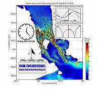
In the animation below we show a large springtide at 7 May 2016 with an interval of 1 minute. A maximum current of around 8 m/s is found in the main channel. Click cc (Choose captions) in the bar below to get more information during the video.
Simulation of tidal current in Saltstraumen (Norway) on 7 May 2016 from Dam Engineering on Vimeo.
In the next animation we show the water level on 7 May 2016 using the FINEL model. The tidal wave that comes from the sea wants to fill Skjerstadfjorden through Saltstraumen and Sundstraumen. Because Salstraumen and Sundstraumen are so narrow there is a large water level difference between the inner and outer fjord. This creates a large current (up to nearly 8 m/s in the animation) in Saltstrauen. The inner basin (Skjerstadfjorden) does not get filled completely in 6 hours time. After 6 hours the ebb starts again and the inner basin empties again. You can see this clearly in the water level plots of Bodo (on the outside) and Tuv (on the inside).
Simulation of water level in and around Saltstraumen (Norway) on 7 May 2016 from Dam Engineering on Vimeo.
The third animation shows the simulation of the water level of the complete computer model. The tidal wave comes from the south, is partly 'catched' by the Lofoten islands in front of the coast and creates there a higher water level than north of the Lofoten islands. Saltstraumen is located near Bodø. The model domain is around 400x600 km, with a coarse grid resolution at sea (10km). The resolution is steadily refined to a final resolution of 3m in Saltstraumen. The triangular shaped mesh is especially suited to follow the rugged coastline of Norway and without complicated nesting techniques this refinement can be carried out easily.
Simulation of water level Nordland and Lofoten (Norway) from Dam Engineering on Vimeo.